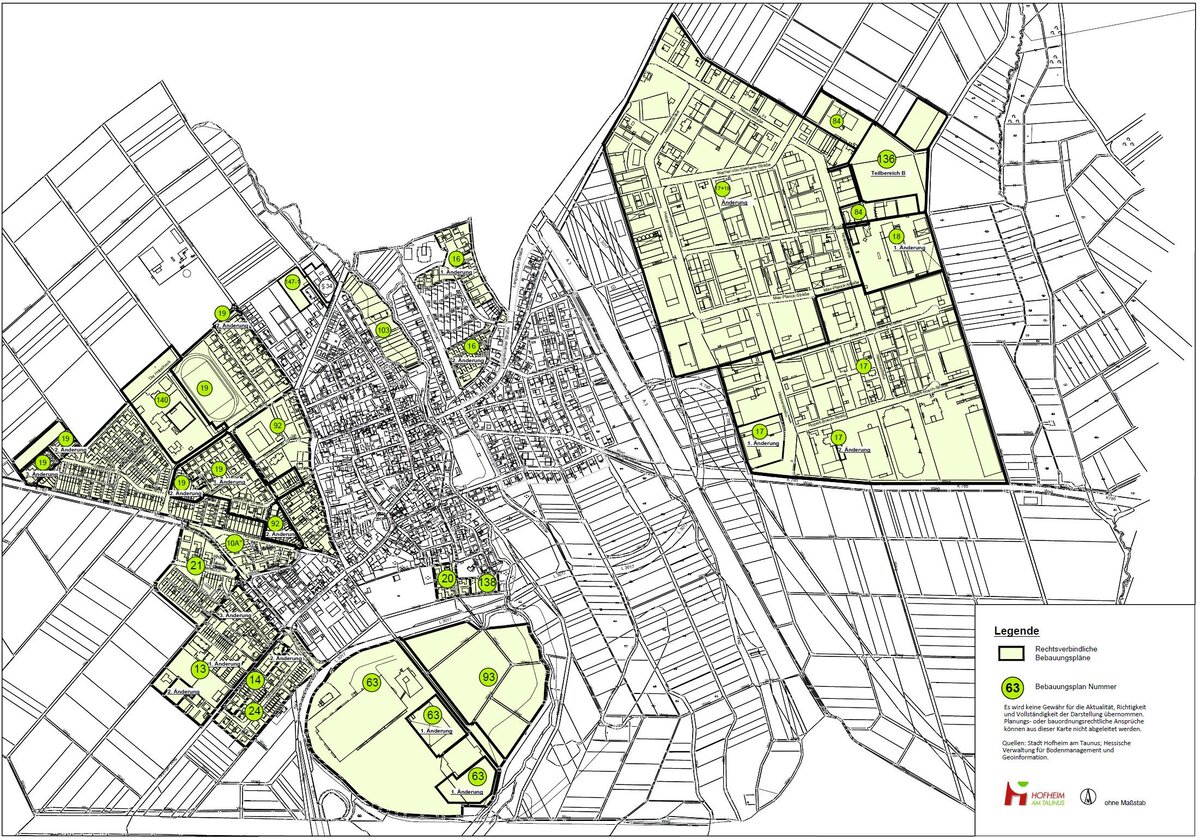
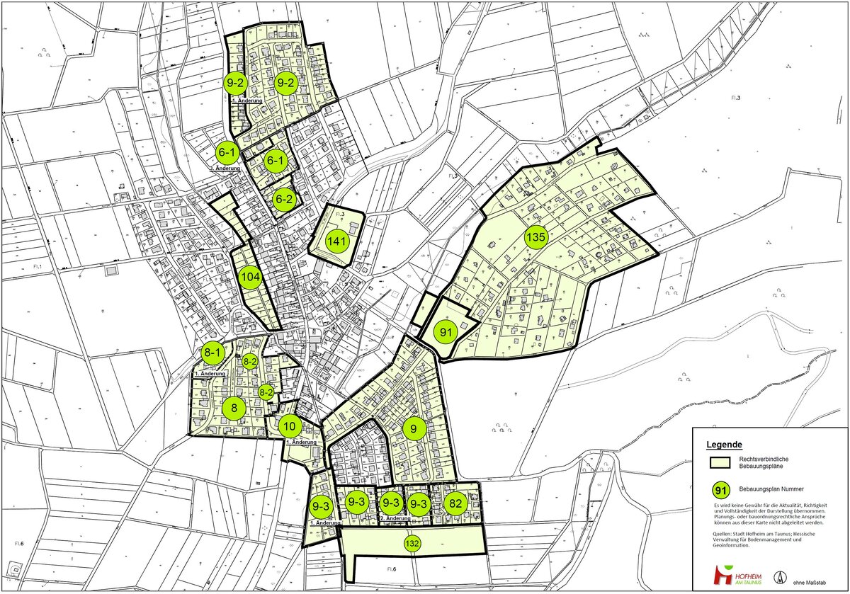
Development plans of the town of Hofheim am Taunus
Note
All files, screen displays and printouts do not constitute legally binding information. No guarantee is given that the information is up-to-date, correct and complete. No claims under planning or building regulations law can be derived from the representations on the Internet.
To clarify whether a property can be built on, please contact the Urban Development Planning team.
As there are development plans whose areas of application extend to both the Hofheim and Marxheim districts, we recommend that you search on both sides if necessary.
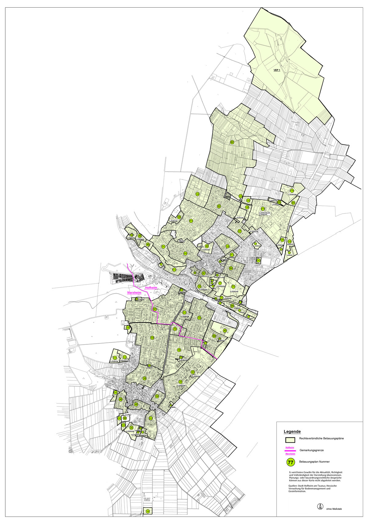
Overview of legally binding development plans by district
Development plans of the city of Hofheim - Here: Core city
Development plans are municipal statutes and contain provisions for urban planning. Valid development plans of the city of Hofheim are available for download on this page.
Note
To clarify whether a property can be built on, please contact the Urban Development Planning team.
- B-Plan Nr. 11 "Östlich des Danziger Weges" (PDF (1,14 MB))
- B-Plan Nr. 12 und 41, 2. Änderung "Gewerbegebiet Langgewann und Gewerbegebiet Nord" incl. 3. Änderung (PDF (6,40 MB))
- B-Plan Nr. 27 incl. der 1. und 2. Änderung (PDF (1,25 MB))
- B-Plan Nr. 27, 1. Änderung (PDF (530,21 KB))
- B-Plan Nr. 27, 2. Änderung (PDF (564,27 KB))
- B-Plan Nr. 29, 1. Änderung "Dr. Rohmer-Weg, Schneidhainer u. tlw. Wingertstraße" (PDF (2,33 MB))
- B-Plan Nr. 41.1 "SO-Finanzamt" (PDF (1,77 MB))
- B-Plan Nr. 42, 1. Änderung "Krankenhaus" (PDF (2,64 MB))
- B-Plan Nr. 42, 2. Änderung "Am Krankenhaus" (PDF (4,48 MB))
- B-Plan Nr. 43 "Am Hochfeld" (PDF (3,86 MB))
- B-Plan Nr. 45 "Lorsbachtal I" (PDF (2,57 MB))
- B-Plan Nr. 45, 1. Änderung "Lorsbachtal I" (PDF (3,92 MB))
- B-Plan Nr. 45, 2. Änderung "Lorsbachtal I" (PDF (1,92 MB))
- B-Plan Nr. 52 "Vorderheide und Steinberg" (PDF (3,55 MB))
- B-Plan Nr. 61 "Distrikte A u. C" (PDF (7,56 MB))
- B-Plan Nr. 61, 1. Änderung "Distrikte A u. C" (PDF (5,17 MB))
- B-Plan Nr. 62 "Bauerlöcher Wiesen" (PDF (5,72 MB))
- B-Plan Nr. 64 "Gebiet zwischen Zeilsheimer-Krifteler Straße und Elisabethen-Ostendstraße (PDF (3,25 MB))
- B-Plan Nr. 65 "Nördlich der Neugasse" (PDF (1,86 MB))
- B-Plan Nr. 65, 2. Änderung "Nördlich der Neugasse" (PDF (2,10 MB))
- B-Plan Nr. 66 "Distrikt F tlw." (PDF (1,75 MB))
- B-Plan Nr. 72 "Östlich der Rheingaustraße" (PDF (3,31 MB))
- B-Plan Nr. 72, 1. Änderung "Östlich der Rheingaustraße" (PDF (2,30 MB))
- B-Plan Nr. 74.1 "Kurhausstraße - Kapellenstraße" (PDF (4,73 MB))
- B-Plan Nr. 74.2 "Kargeswiesen" (PDF (3,58 MB))
- B-Plan Nr. 75 "Alte Bleiche" (PDF (3,10 MB))
- B-Plan Nr. 75, 1. Änderung Teilbereich A "Alte Bleiche" (PDF (3,65 MB))
- B-Plan Nr. 75, 2. Änderung "Alte Bleiche" (PDF (4,16 MB))
- Begründung B-Plan Nr. 75, 2. Änderung "Alte Bleiche" (PDF (1,96 MB))
- B-Plan Nr. 77, 1. Änderung "Brühlwiesen" (PDF (3,37 MB))
- B-Plan Nr. 77, 2. Änderung "Brühlwiesen" (PDF (3,47 MB))
- B-Plan Nr. 77, 3. Änderung "Brühlwiesen" (PDF (2,96 MB))
- B-Plan Nr. 80 "Am Hochfeld" (PDF (3,64 MB))
- B-Plan Nr. 80, 1. Änderung "Am Hochfeld" im Bereich Schoppastraße (PDF (125,23 KB))
- B-Plan Nr. 81 "Gewerbegebiet Nord II" (PDF (1,52 MB))
- B-Plan Nr. 85, 1. Änderung "Gewerbegebiet Nord III" (PDF (4,57 MB))
- B-Plan No. 85, 2nd amendment "Gewerbegebiet Nord III" (PDF (5,56 MB))
- Explanatory statement for B-Plan No. 85, 2nd amendment "Gewerbegebiet Nord III" (PDF (3,74 MB))
- B-Plan Nr. 87 "Westlich der Rheingaustraße" (Vorderseite der Plankopie) (PDF (3,03 MB))
- B-Plan Nr. 87 "Westlich der Rheingaustraße" (Rückseite der Plankopie) (PDF (1,13 MB))
- B-Plan Nr. 87, 1. Änderung "Westlich der Rheingaustraße im Quartier Flosswaldstraße - Vencenzstraße" (PDF (1,81 MB))
- B-Plan Nr. 87, 2. Änderung "Westlich der Rheingaustraße, Forsthaus" (PDF (2,09 MB))
- B-Plan Nr. 88 "Südlich der Hattersheimer Straße" (PDF (2,47 MB))
- B-Plan Nr. 116 "Feuerwehrstation Hofheim Teilbereich 1" (PDF (4,40 MB))
- B-Plan Nr. 116, 1. Änderung "An der Feuerwache Hofheim" (PDF (3,20 MB))
- B-Plan Nr. 118.1 "Zeilsheimer Straße und Liederbacher Weg" (PDF (3,04 MB))
- B-Plan Nr. 119, 1. Änderung "Neues Hallenbad Hofheim Rhein-Main-Therme" (PDF (2,94 MB))
- B-Plan Nr. 120.1 "Wohngebiet östlich des Kapellenberges" (PDF (4,44 MB))
- B-Plan Nr. 120.3 "Wohngebiet nördlich der Kurhausstraße" (PDF (4,85 MB))
- B-Plan Nr. 129 "Quartier Zeil-Feldstraße" (PDF (3,90 MB))
- B-Plan Nr. 131 "Pflegeheim Schwarzbachweg" (PDF (2,67 MB))
- B-Plan Nr. 133 "Im Langgewann II" (PDF (3,07 MB))
- B-Plan Nr. 133, Teil B "Im Langgewann II - Erweiterung" (PDF (3,84 MB))
- Begründung Bebauungsplan Nr. 133 Teil B im Langgewann II Erweiterung (PDF (7,63 MB))
- Umweltbericht: B-Plan Nr. 133, Teil B "Im Langgewann II - Erweiterung" (PDF (1,68 MB))
- B-Plan Nr. 137.1, Teilbereich A "Zeilsheimer und Niederhofheimer Straße" (PDF (3,93 MB))
- Vorhabenbezogener B-Plan Nr. 137.2 "Wohngebiet an der Homburger Straße" (PDF (4,50 MB))
- Begründung zum Vorhabenbezogenen B-Plan Nr. 137.2 "Wohngebiet an der Homburger Straße" (PDF (7,46 MB))
- B-Plan Nr. 143 "Östlich der Höchster Straße" (PDF (3,38 MB))
- Begründung: B-Plan Nr. 143 "Östlich der Höchster Straße" (PDF (4,41 MB))
- B-Plan Nr. 146 "Im Langgewann III" (PDF (3,36 MB))
- Begründung: B-Plan Nr. 146 "Im Langgewann III" (PDF (616,78 KB))
- Vorhaben- und Erschließungsplan VEP 1, 1. Änderung "Golfplatz Hof Hausen vor der Sonne" (PDF (4,03 MB))
- Vorhaben- und Erschließungsplan VEP 3, 1. Änderung "Am Klingenborn" (PDF (2,87 MB))
- Vorhaben- und Erschließungsplan VEP 8 "Wohngebiet Königsteiner Straße - Langgewann" (PDF (2,34 MB))
- B-Plan Nr. 152 Hattersheimer Straße (PDF (12,81 MB))
Development plans of the city of Hofheim - Here: Marxheim
Development plans are municipal statutes and contain provisions for urban planning. Valid development plans of the city of Hofheim are available for download on this page.
Note
To clarify whether a property can be built on, please contact the Urban Development Planning team.
- B-Plan Nr. 10 1. Änderung "Heiligenstock" (PDF (2,66 MB))
- B-Plan Nr. 10 "Heiligenstock" (PDF (2,93 MB))
- B-Plan Nr. 23-3 "Oberhalb der Weilbacher Strasse" (PDF (3,08 MB))
- B-Plan Nr. 23-3 1. Änderung "Oberhalb der Weilbacher Straße" (PDF (4,32 MB))
- B-Plan Nr. 24 "Hofheimer Straße tlw., Odenwaldstr., Taunusstraße, Rhönstraße und Klarastraße" (PDF (2,55 MB))
- B-Plan Nr. 28 1. Änderung (PDF (678,43 KB))
- B-Plan Nr. 28 "Gebiet zwischen Bahnstraße, Klarastr., Schloßstraße und Amselweg" (PDF (3,77 MB))
- B-Plan Nr. 31-1, 1. Änderung "Sachsenring" (PDF (4,12 MB))
- B-Plan Nr. 31, 2. Änderung "Gebiet am Sachsenring) (PDF (3,14 MB))
- B-Plan Nr. 31, 3. Änderung Sachsenring (Thüringer Weg) (PDF (3,06 MB))
- B-Plan Nr. 32, 1. Änderung "Für das Gebiet der Diedenbergener Str." (PDF (2,84 MB))
- B-Plan Nr. 32, 2. Änderung "Bereich Bauhof" (PDF (717,62 KB))
- B-Plan Nr. 32, 3. Änderung "Für das Gebiet Diedenbergener Straße" (PDF (1,25 MB))
- B-Plan Nr. 32, 4. Änderung "Einzelhandelsstandort/ Kulturzentrum Ahornstraße" (PDF (3,67 MB))
- B-Plan Nr. 40 "Apfelgarten" (PDF (2,70 MB))
- B-Plan Nr. 48 "Pfingstbrunnen" (PDF (1,72 MB))
- B-Plan Nr. 72 "Östlich der Rheingaustrasse" (PDF (3,31 MB))
- B-Plan Nr. 72, 1. Änderung "Östlich der Rheingaustraße" (PDF (2,30 MB))
- B-Plan Nr. 87 "Westlich der Rheingaustrasse" (Rückseite des Plans) (PDF (1,13 MB))
- B-Plan Nr. 87 "Westlich der Rheingaustrasse" (Vorderseite des Plans) (PDF (3,03 MB))
- B-Plan Nr. 87, 1. Änderung "Westlich der Rheingaustraße" (PDF (1,81 MB))
- B-Plan Nr. 87, 2. Änderung "Westlich der Rheingaustraße" (PDF (2,09 MB))
- B-Plan Nr. 96 "Borngarten" (PDF (3,38 MB))
- B-Plan Nr. 110-1 "Wohnungsferne Gärten - Borngarten" (PDF (1,54 MB))
- B-Plan Nr. 110-2 "Wohnungsferne Gärten - Ranzenbrunnen" (PDF (1,51 MB))
- B-Plan Nr. 117 "Haus vom Guten Hirten" (PDF (4,24 MB))
- B-Plan Nr. 117, 1. Änderung "Haus vom Guten Hirten" (PDF (2,80 MB))
- B-Plan Nr. 121 "Westlich der Rheingaustrasse zwischen Am Peterswald und Amselweg" (PDF (5,61 MB))
- B-Plan Nr. 139 "Wohngebiet Rosenberg" (PDF (3,25 MB))
- B-Plan Nr. 139 Planbegründung "Wohngebiet Rosenberg" (PDF (673,81 KB))
- B-Plan Nr. 150 "Rechenzentrum Marxheim" Begründung (PDF (2,47 MB))
- B-Plan Nr. 150 "Rechenzentrum Marxheim" (PDF (8,41 MB))
- B-Plan Nr. 150 "Rechenzentrum Marxheim" Zusammenfassende Erklärung (PDF (446,64 KB))
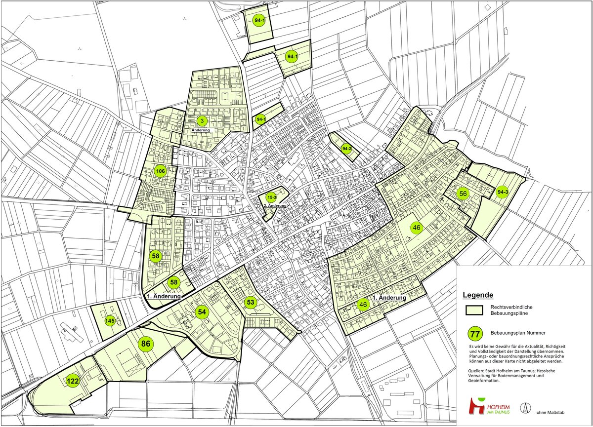
Development plans of the town of Hofheim am Taunus - Here: Diedenbergen
Development plans are municipal statutes and contain provisions for urban planning. Valid development plans of the city of Hofheim are available for download on this page.
Note
To clarify whether a property can be built on, please contact the Urban Development Planning team.
- B-Plan Nr. 3, Änderung "In der Flachskaut" (PDF (1,20 MB))
- B-Plan Nr. 15-3, 2. Änderung "Durch den Hirtenpfad" (PDF (2,56 MB))
- B-Plan Nr. 46 "Beiderseits der Friedhofstraße" (PDF (4,46 MB))
- B-Plan Nr. 46, 1. Änderung (PDF (786,76 KB))
- B-Plan Nr. 53 "Zwischen Wickerer Weg und Schwarzwaldstraße" (PDF (1,81 MB))
- B-Plan Nr. 54 "Gewerbegebiet Diedenbergen" (PDF (1,99 MB))
- B-Plan Nr. 56 "Südlich vom Tiefen Graben" (PDF (1,31 MB))
- B-Plan Nr. 58 "Querspange" (PDF (2,12 MB))
- B-Plan Nr. 58, 1. Änderung "Querspange" (PDF (2,68 MB))
- B-Plan Nr. 86 "Gewerbegebiet Diedenbergen II" (PDF (3,60 MB))
- B-Plan Nr. 94-1 "Wohnungsferne Gärten - Östlich der Wildsachsener Straße" (PDF (1,83 MB))
- B-Plan Nr. 94-2 "Wohnungsferne Gärten oberhalb der Marxheimer Straße" (PDF (1,32 MB))
- B-Plan Nr. 94-3 "Wohnungsferne Gärten zwischen Dachsweg und Tiefer Graben" (PDF (4,20 MB))
- B-Plan Nr. 106 "Westlich des Bussardsweges" (PDF (5,00 MB))
- B-Plan Nr. 122 "Gewerbegebiet Diedenbergen III" (PDF (2,25 MB))
- VEP Nr. 145 "Gewerbegebiet nördlich der Casteller Straße" Teilbereich A (PDF (3,81 MB))
- Begründung Teil 1: VEP Nr. 145 "Gewerbegebiet nördlich der Casteller Straße" Teilbereich A (PDF (2,20 MB))
- Begründung Teil 2: VEP Nr. 145 "Gewerbegebiet nördlich der Casteller Straße" Teilbereich A (PDF (1,74 MB))
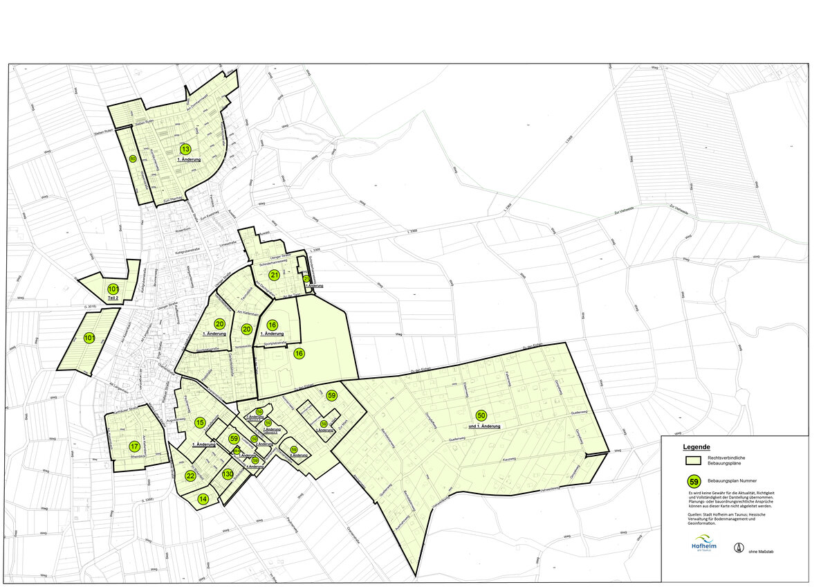
Development plans of the town of Hofheim am Taunus - Here: Langenhain
Development plans are municipal statutes and contain provisions for urban planning. Valid development plans of the city of Hofheim are available for download on this page.
Note
To clarify whether a property can be built on, please contact the Urban Development Planning team.
- B-Plan Nr. 13, 1. Änderung "Beiderseits der Eppsteiner Straße" incl. Änderung Dachflächengestaltung (PDF (3,02 MB))
- B-Plan Nr. 14, Änderung "Im Birkenfeld" (PDF (1,50 MB))
- B-Plan Nr. 15 "Paulinenweg" (PDF (1,61 MB))
- B-Plan Nr. 16 "Am Sportplatz" (PDF (3,55 MB))
- B-Plan Nr. 16, 1. Änderung "Am Sportplatz" Teilbereich A (PDF (1,14 MB))
- B-Plan Nr. 17 "Am Herrengarten" (PDF (1,87 MB))
- B-Plan Nr. 20 "Beiderseits der Gartenfeldstraße" (PDF (1,18 MB))
- B-Plan Nr. 20 "Beiderseits der Gartenfeldstraße" 1. Änderung (PDF (2,65 MB))
- B-Plan Nr. 21, "Beiderseits der Usinger Straße" (PDF (1,39 MB))
- B-Plan Nr. 21, 1. Änderung "Beiderseits der Usinger Straße" (PDF (555,58 KB))
- B-Plan Nr. 22 "Birkenfeld II" (PDF (1,49 MB))
- B-Plan Nr. 50 "Weilbächer Wälder" (PDF (4,90 MB))
- B-Plan Nr. 50, 1. Änderung "Weilbächer Wälder" (PDF (889,25 KB))
- B-Plan Nr. 59 "Südlich zu den Eichen" (Rückseite des Plans) (PDF (2,27 MB))
- B-Plan Nr. 59 "Südlich zu den Eichen" (Vorderseite des Plans) (PDF (3,03 MB))
- B-Plan Nr. 59, 2. Änderung "Südlich zu den Eichen" (PDF (2,52 MB))
- B-Plan Nr. 59, 3. Änderung "Südlich zu den Eichen" (PDF (2,34 MB))
- B-Plan Nr. 59, 4. Änderung "Südlich zu den Eichen" (PDF (2,25 MB))
- B-Plan Nr. 59, 6. Änderung "Südlich zu den Eichen" (PDF (2,46 MB))
- B-Plan Nr. 59, 7. Änderung "Südlich zu den Eichen" (PDF (3,24 MB))
- B-Plan Nr. 59, 7. Änderung "Südlich zu den Eichen" Teilbereich B (PDF (5,26 MB))
- B-Plan Nr. 59.4, 1. Änderung "Paulinenweg" (PDF (3,03 MB))
- Begründung: B-Plan Nr. 59.4, 1. Änderung "Paulinenweg" (PDF (342,74 KB))
- B-Plan Nr. 60 "Westlich der Wiesenstraße" (PDF (1,19 MB))
- B-Plan Nr. 101 "Wohnungsferne Gärten westlich der Ortslage am Kasernbach" (PDF (1,72 MB))
- B-Plan Nr. 101 Teil 2 "Wohnungsferne Gärten westlich der Ortslage am Kasernbach" (PDF (3,25 MB))
- B-Plan Nr. 130 "Paulinenweg - Im Birkenfeld" (PDF (2,01 MB))
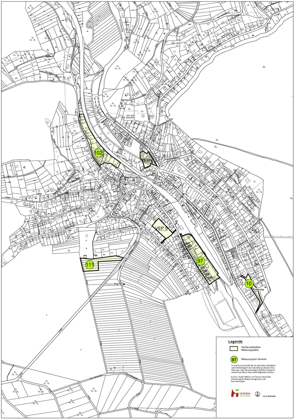
Development plans of the town of Hofheim am Taunus - Here: Lorsbach
Development plans are municipal statutes and contain provisions for urban planning. Valid development plans of the city of Hofheim are available for download on this page.
Note
To clarify whether a property can be built on, please contact the Urban Development Planning team.
- VEP Nr. 5 "Am Hang" (PDF (1,83 MB))
- VEP Nr. 6 "Seniorenwohnanlage für betreutes Wohnen" (PDF (1,66 MB))
- B-Plan Nr. 10, Änderung (PDF (447,54 KB))
- B-Plan Nr. 97 "Turnhalle am Schinderwald" (PDF (2,75 MB))
- B-Plan Nr. 102 "Wohnungsferne Gärten zwischen Neueburgstraße und DB" (PDF (1,96 MB))
- B-Plan Nr. 111 "Friedhof Lorsbach - Erweiterung" (PDF (1,68 MB))
Development plans of the town of Hofheim am Taunus - Here: Wallau
Development plans are municipal statutes and contain provisions for urban planning. Valid development plans of the city of Hofheim are available for download on this page.
Note
To clarify whether a property can be built on, please contact the Urban Development Planning team.
- B-Plan Nr. 10a "Haingraben II" (PDF (2,69 MB))
- B-Plan Nr. 13, 1. Änderung "Gräsiger Weg I" (PDF (1,43 MB))
- B-Plan Nr. 13, 2. Änderung "Gräsiger Weg I" (PDF (214,42 KB))
- B-Plan Nr. 13, 3. Änderung "Gräsiger Weg I" (PDF (531,41 KB))
- B-Plan Nr. 14, 2. Änderung "Gräsiger Weg II" (PDF (1,15 MB))
- B-Plan Nr. 16, 1. Änderung "Hühnerberg" (PDF (1,60 MB))
- B-Plan Nr. 16, 2. Änderung "Hühnerberg" (PDF (1,52 MB))
- B-Plan Nr. 17 "Gewerbegebiet Wallau Ost" (PDF (2,38 MB))
- B-Plan Nr. 17, 1. Änderung "Gewerbegebiet Wallau Ost" (PDF (2,02 MB))
- B-Plan Nr. 17, 2. Änderung "Gewerbegebiet Wallau Ost" (PDF (2,35 MB))
- B-Plan Nr. 17 u. 18, Änderung "Gewerbegebiet Wallau Ost" (PDF (1,47 MB))
- B-Plan Nr. 18, 1. Änderung "Gewerbegebiet Wallau Ost II" (PDF (3,10 MB))
- B-Plan Nr. 19 "An der Schule" (PDF (2,55 MB))
- B-Plan Nr. 19, 1. Änderung "An der Schule" (PDF (2,06 MB))
- B-Plan Nr. 19, 2. Änderung "An der Schule" (PDF (2,39 MB))
- B-Plan Nr. 19, 3. Änderung "An der Schule" (PDF (487,33 KB))
- B-Plan Nr. 20 "Nachtschatten" (PDF (1,59 MB))
- B-Plan Nr. 21 "Wallau West" (PDF (1,25 MB))
- B-Plan Nr. 24 "Bleidenstädter Äcker" (PDF (709,43 KB))
- B-Plan Nr. 63 "Ikea Wallau" (PDF (2,88 MB))
- B-Plan Nr. 63, 1. Änderung "Ikea Wallau" (PDF (1,86 MB))
- B-Plan Nr. 84, 1. Änderung "Unterm Weißen Stein" (PDF (3,00 MB))
- B-Plan Nr. 92 (PDF (3,62 MB))
- B-Plan Nr. 92, 2. Änderung (PDF (2,73 MB))
- B-Plan Nr. 93 "Kleingärten Wallau" (PDF (3,58 MB))
- B-Plan Nr. 103 "Wohnungsferne Gärten zwischen Wickerbach und Bleichstraße" (PDF (1,97 MB))
- B-Plan Nr. 136B "Gewerbegebiet Wallau" Teilbereich B (PDF (5,15 MB))
- B-Plan Nr. 138 "Am Nachtschatten" (PDF (2,86 MB))
- B-Plan Nr. 140 "Taunusblickschule Neubau Ländcheshalle" (PDF (3,74 MB))
- B-Plan Nr. 147-1 "Nordöstlich der oberen Taunusstraße" (PDF (3,52 MB))
- Einbeziehungssatzung "Obere Taunusstraße" (PDF (3,67 MB))
Development plans of the town of Hofheim am Taunus - Here: Wildsachsen
Development plans are municipal statutes and contain provisions for urban planning. Valid development plans of the city of Hofheim are available for download on this page.
Note
To clarify whether a property can be built on, please contact the Urban Development Planning team.
- B-Plan Nr. 6-1, 1. Änderung "Oberm Bremthalerweg" (PDF (736,09 KB))
- B-Plan Nr. 6-1, 2. Änderung "Oberm Bremthalerweg" (PDF (628,13 KB))
- B-Plan Nr. 6-1, 3. Änderung "Oberm Bremthalerweg" (PDF (324,78 KB))
- B-Plan Nr. 8 "Münchhecke" (PDF (1,95 MB))
- B-Plan Nr. 8, 1. Änderung "Münchhecke" (PDF (347,23 KB))
- B-Plan Nr. 8, 2. Änderung "Münchhecke" (PDF (282,46 KB))
- B-Plan_Nr._9-2_Oberm_Bremthaler_Weg_II.pdf (PDF (2,99 MB))
- B-Plan Nr. 9-2, Änderung "Oberm Bremthaler Weg II" (PDF (248,01 KB))
- B-Plan Nr. 9-3 "Am Naturfreundehaus" (PDF (1,89 MB))
- B-Plan Nr. 9-3, 1. Änderung "Am Naturfreundehaus" (PDF (539,69 KB))
- B-Plan Nr. 9-3, 2. Änderung "Am Naturfreundehaus" (PDF (2,19 MB))
- B-Plan Nr. 9 "Östlich der Langenhainerstraße" (PDF (2,50 MB))
- B-Plan Nr. 10, 1. Änderung "Münchhecke u. Östlich der Langenhainer Straße" (PDF (1,73 MB))
- B-Plan Nr. 82 "Südlich Lotzenwald" (PDF (2,56 MB))
- B-Plan Nr. 91 "Sportanlage am Hollerbach" (PDF (2,21 MB))
- B-Plan Nr. 104 "Grabgärten entlang des Seyenbachs" (PDF (1,88 MB))
- B-Plan Nr. 132 "Jungehag" (PDF (4,90 MB))
- B-Plan Nr. 132 „Jungehag“ - Begründung mit Umweltbericht und Zusammenfassender Erklärung (PDF (9,90 MB))
- B-Plan Nr. 135 "Junghainzehecken" (PDF (5,11 MB))
- B-Plan Nr. 141 "Dorfgemeinschaftsplatz Wildsachsen" (PDF (3,13 MB))


